We often pass rotundas or roundabouts while driving around Metro Manila, but have you ever stopped to think about what purpose roundabouts serve and the history behind them? Or maybe you’re just wondering how to drive properly on a roundabout and which vehicle has the right of way? This is an actual LTO exam question to get a driver’s license, so read on to the end if you want to find out.
A rotunda, also known as a roundabout, rotary or traffic circle is a traffic scheme where three or more roads join and traffic must go around in one direction only around a circular area in the middle rather than straight across. Roundabouts don’t refer to a geometric shape and they’re not always round. In fact, most are elliptical (as seen in Quezon City’s Elliptical Road) or some variation of a circle, while others have irregular or angular shapes, while still managing intersecting traffic.
In his 2001 column Rotundas: Circles of Urban Life, landscape architect and urban planner Paulo Alcazaren wrote that back in the day, rotundas were “classic elements to be found in all civilized cities in the world,” with Manila once counted among those cities. He described how streets like Taft Avenue and EDSA (then called Highway 54) still had huge acacia trees that offered shade, landscaped islands separating main roads from service streets, and actual sidewalks, with roundabouts serving as decorative road accents.
According to Alcazaren, some roundabouts in the Philippines (such as the Carriedo Fountain Rotunda) trace their roots to the colonial period, while others emerged as part of urban planning and transportation management strategies prepared by American city planner and architect Daniel Burnham. Apparently, some rotundas were designed and built as part of a grand transport network meant to “link sections of the city via wide, tree-lined avenues, fountain or monument-embellished rotundas and pedestrian-friendly sidewalks or landscaped parkways.”
ALSO READ:
3 Steps to easily conquer a roundabout
How to avoid car accidents
While the plans sound like a dream, sadly, the metro’s streets are more of a nightmare to navigate these days. With rapid urbanization, many historic monuments have disappeared and existing ones are rarely given a second thought.
In honor of Independence Day in June and Heritage Month in May, let’s take a closer look at some of the historic roundabouts that are still around.
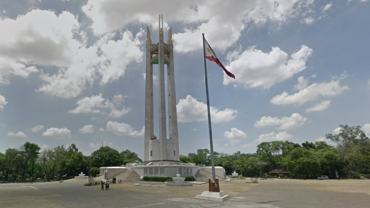
Quezon Memorial Circle (QC Circle)

Elliptical Road is a 1.98km roundabout that goes around the Quezon Memorial Circle in Quezon City. It’s a vital thoroughfare, connecting several major roads including Commonwealth Avenue, Visayas Avenue, Quezon Avenue, East Avenue, Kalayaan Avenue and Maharlika Street, serving as a central point for the city’s busy transport network. Made up of eight lanes and multiple exit points, this roadway is notorious for drivers who swerve and switch lanes scrambling to get to the right exit.
Ever wondered why QC Circle is so huge compared to other roundabouts which usually just have two lanes? The earliest known plan involving the roundabout follows the original urban plan for Quezon City, approved in 1941. QC Circle was supposed to be the grounds of the National Capitol and the Congress of the Philippines. Its location was part of a larger ‘National Government Center’ located around Elliptical Road and the Quezon City Quadrangle (made up of the North, South, East, and West Triangles). However, Quezon City only served as the capital of the Philippines until 1976. Plans didn’t pan out when the capital was moved back to Manila due to its historical significance as the seat of government since the Spanish Period.
Today, QC Circle serves as a rather overlooked recreational park with huge trees, shaded walkways, and several notable museums including the Presidential Car Museum, Quezon Heritage House, and the towering Quezon Memorial Shrine, dedicated to the second President of the Philippines, Manuel L. Quezon. The park also serves as a venue for various events and gatherings. Sections under QC Circle are currently undergoing major developments with the stations for the Metro Rail Transit (MRT) station located on the MRT Line 7 under construction and an elevated walkway connecting to Ninoy Aquino Parks and Wildlife.
QC Circle is also being redeveloped as a major green area with some cemented structures to be removed in favor of 70 percent picnic grounds and children’s playgrounds, themed gardens, areas for urban farming, wider path walks, bike lanes, jogging paths, and exercise areas.
Welcome Rotonda / Mabuhay Rotunda
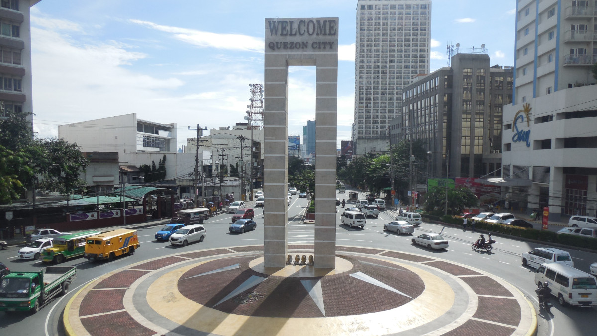
Officially named Mabuhay Rotunda, though commonly referred to as ‘Welcome Rotonda,’ or simply ‘Welcome,’ this circular junction marks the boundary of Quezon City and Manila. The roundabout lies at the intersection of E. Rodriguez, Sr. Boulevard, Mayon Avenue, Quezon Avenue, Nicanor Ramirez Street, and España Boulevard.
The roundabout was first opened in 1948, with a marble monument designed by Luciano V. Aquino erected at its center. Its original name "Mabuhay" translates to "long live" in Filipino, a common Filipino greeting and was designed to welcome visitors when Quezon City was the capital. The monument is surrounded by four lions pointing to the north, south, east and west.
Over the years, Mabuhay Rotunda has become a common convergence point for rallies and protests. From here, protesters often march south to Mendiola or Liwasang Bonifacio or north towards Batasang Pambansa.
Anda Circle
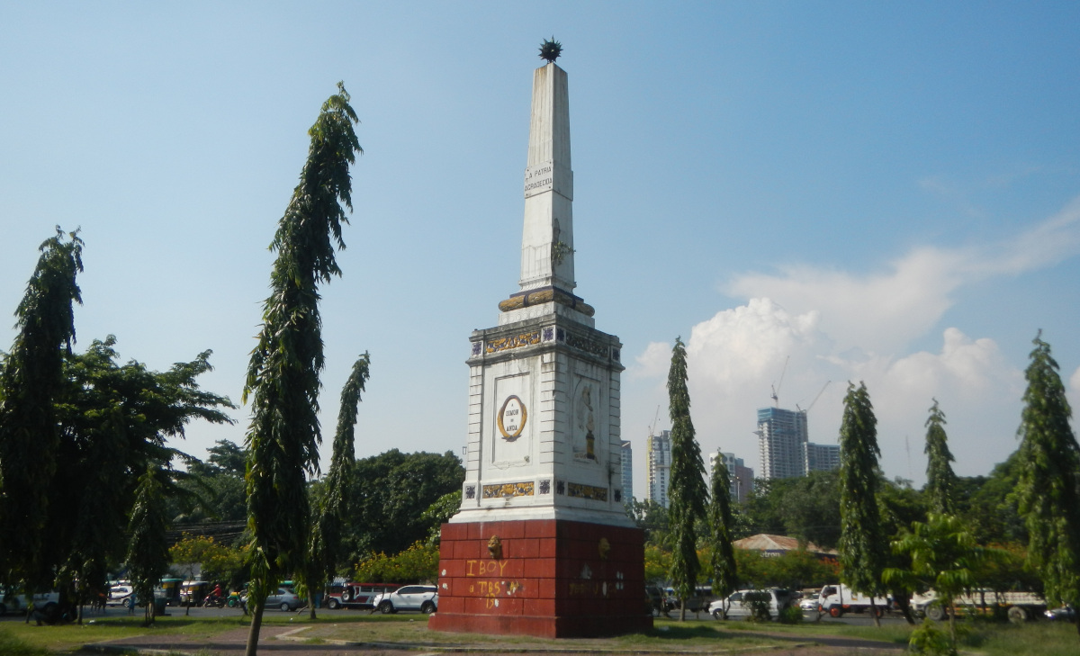
On your way to and from Intramuros, you’ve no doubt come across Anda Circle, a roundabout located at the boundary of Intramuros and Port Area in central Manila, Philippines. This interchange system at the junction of Bonifacio Drive, Mel Lopez Boulevard, Andres Soriano Avenue (formerly Calle Aduana) and Robert Oca Street, serves as a gateway to the Walled City. The Anda Monument is an obelisk monument situated inside the roundabout that was erected in honor of Simón de Anda y Salazar, the appointed Governor General of the Philippines from 1770 to 1776.
This historic monument was originally built in 1871 near the Pasig River though it was heavily damaged during the war. After the war, it was moved to its present location at the rotunda and was retransformed into a monument circle. In 2020, the monument was repainted the same color as the original. Multi-colored lights and a fountain were also installed, making it much more attractive at night.
Remedios Circle
Remedios Circle, also known as the Plaza de la Virgen de los Remedios, Remedios Rotonda, and Rotary Circle, is a traffic circle in Malate, Manila. It serves as the intersection between Remedios Street, Jorge Bocobo Street and Adriatico Street. The circle and a traversing street are both named after Nuestra Señora de los Remedios (Our Lady of Remedies), the patroness of the nearby Malate Church, and is one of two major open spaces in Malate—the other being Plaza Rajah Sulayman.
Did you know that Remedios Circle was originally a cemetery during colonial times? According to a Rappler report featuring cemetery trivia, Remedios Circle used to be one of Manila’s earliest cemeteries (alongside Paco Cemetery). However, it was demolished after World War II, while remains were re-buried in the South Cemetery. The Catholic Church turned over the cemetery to the government to build an access road that led to a new church across the Manila Zoo.
Boy Scout Circle / 11th World Scout Jamboree Memorial Rotunda
If you frequent the Timog and Morato area in Quezon City for its restaurants, you’ve likely passed by the Boy Scout Circle. Officially called the 11th World Scout Jamboree Memorial Rotonda, this roundabout located at the intersection between Timog and Tomas Morato Avenues serves as the boundary between Barangays South Triangle, Laging Handa and Sacred Heart.
Ever wonder why there are statues of Boy Scouts here and why all the streets in the Timog area have ‘Scout’ in their names? The monument commemorates the members of the ill-fated Philippine contingent who were casualties of a flight crash in 1963. The circular pedestal with bronze statues represents the 24 members of the Philippine delegation (22 Boy Scouts, two veteran Scouters, and two chaperons) around the structure.
In his column, “Street names: Remembering and forgetting” historian Ambeth Ocampo explains how multiple streets in the district now known as “Laging Handa” (the Scout motto) were renamed for the fallen Scouts: Albano, Bayoran, Borromeo, Madriñan, Rallos, Limbaga, Fernandez, Fuentebella, Gandia, De Guia, Delgado, Lozano, Castor, Ojeda, Chuatoco, Magbanua, Reyes, Santiago, Tobias, Tuason, Torillo, and Ybardaloza. Meanwhile, Dr. Lazcano and Fr. Martinez were the head of the Philippine delegation and chaplain.
The statues were sculpted by Florante Beltran Caedo and the monument was unveiled to the public in 1965 by then-Mayor Norberto S. Amoranto at the intersections of Sampaloc and South avenues (now Tomas Morato and Timog avenues, respectively). In 2007, the Quezon City government renovated the monument to include the addition of an obelisk honoring Tomas Morato, the first mayor of Quezon City, for whom Tomas Morato Avenue is named.
While it’s easy to overlook road landmarks and monuments as we navigate the madness of Metro Manila’s constant gridlock, there’s a lot of history in our streets if we take a closer look.
ALSO READ:
You can get fined as much as P3,000 for these driver’s license violations
11 Traffic violations that you may not have known about
More on roundabouts / rotundas
How do roundabouts affect traffic flow?
So, do roundabouts really ease traffic? The circular junctions, characterized by their continuous flow of traffic around a central island, offer advantages over intersections with traffic lights. Since there’s no need to wait for the lights to change, delays and idling time for vehicles are minimized. Roundabouts can minimize traffic bottlenecks in urban environments, provided road users know how to use them correctly.
Who has the right of way in a roundabout?
There’s always some confusion when it comes to determining who has the right of way, but LTO has set the record straight about who goes first when it comes to roundabouts and merging. In general, vehicles already inside the roundabout have the right of way. Here's a breakdown of their right of way rules at a roundabout regarding vehicles, pedestrians, and road users:
- Vehicles within a roundabout have the right of way over those about to enter
- When merging onto a highway, yield to vehicles already on the highway
- If a car has made a full stop on a side street before merging, it has the right of way.
- Additionally, pedestrians always have the right of way at crosswalks within business or residential districts.
How do I navigate a roundabout?
The Philippines is a left-hand drive country that drives on the right side of the road. Thus, when approaching roundabouts, the flow of traffic should be counterclockwise. Drivers should never take a shortcut and turn left before a center island, as this is illegal and can lead to accidents. Always proceed to the right of the central island and circle it counterclockwise.
As previously explained by Top Gear Philippines, driving around rotundas can be tricky. The bigger the roundabout, the more daunting it might seem, especially for newbie drivers. It can also be challenging when other road users suddenly swerve or don’t stay in the proper lane to exit.
Here are some tips to keep in mind while driving in a roundabout.
- Slow down as you approach the roundabout
- Wait for a decent opening and enter with caution
- Stay on your lane until you make your exit
- If you miss your exit, you can always go around again
When exiting the roundabout, make sure to use your turn signal to indicate your intention to exit. While this is not always followed in the country, drivers must yield to pedestrians in crosswalks.