Do you know how our roads are classified under the Philippine road network? What’s the difference between national roads, circumferential roads, and radial roads?
In case you missed the news, the Metropolitan Manila Development Authority (MMDA) will be prohibiting e-vehicles, such as e-bikes and e-trikes, as well as tricycles, pedicabs, pushcarts, and kuligligs on certain roads in Metro Manila starting April 2024.
Over the years, several laws and orders have been passed regarding the classification of roads in the Philippines. The Department of Public Works and Highways (DPWH) currently uses Department Order No. 133 Series of 2018 to differentiate our roads based on their functionality in relation to the road network.
OTHER STORIES YOU MIGHT HAVE MISSED:
Explainer: What e-bike users need to know about the road bans and license requirements
LTO driver’s license application and renewal guide: Requirements and fees in 2023
National Roads
National Roads are the main routes or priority corridors, or the national primary roads that connect three or more cities. National Roads, can be further classified into three types, namely Primary, Secondary, and Tertiary Roads, with their own specific uses.
National Primary Roads are roads with contiguous road sections extending that connect major cities. Primary roads make up the main trunk line or backbone of the National Road System.
National Secondary Roads are roads that connect cities directly to national primary roads. They also directly connect to major ports, major ferry terminals, major airports, tourist service centers, and major government infrastructure to National Primary Roads. They also directly connect provincial capitals within the same region.
National Tertiary Roads are other existing roads under the DPWH that perform a local function.
Both Primary and Secondary roads may also be named as Bypass Roads or Diversion Roads. Bypass Roads are intended to avoid or ‘bypass’ a built-up area, town, or barangay to let through traffic flow without interference from local traffic, to reduce congestion in the built-up area, and to improve road safety.
Meanwhile, Diversion Roads are roads that directly divert the flow of traffic from one area to another or direct the flow of traffic from the usual route to another to reach the same destination at the same time reducing travel time/distance and lessening vehicle operating costs of road users. Generally, Diversion Roads are shorter than Bypass Roads.
These types of roads can be found all over the Philippines, including in the National Capital Region or Metro Manila indicated by the red, blue, and green lines in the map below.
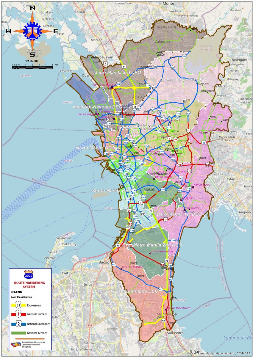
National Route 1 or N1, the north-south backbone refers to the main trunkline of the Pan-Philippine Highway (also designated as Asian Highway 26). This road network which runs from Laoag in the northernmost parts of Luzon to Zamboanga City in western Mindanao connects the country's major islands. Measuring 3,379.73 kilometers long (excluding sea routes not counted by highway milestones), N1 is considered the longest road in the country.
Circumferential and Radial Roads
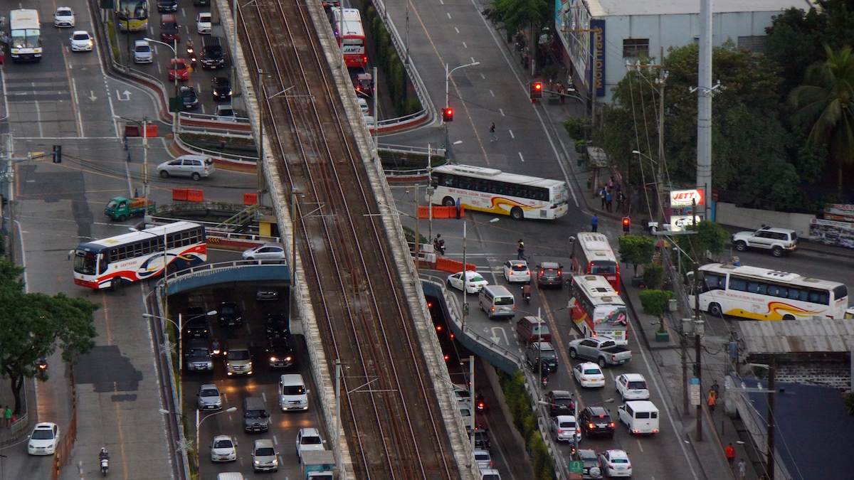
According to DPWH road data, Metro Manila's major road network currently comprises six circumferential roads and ten radial roads which connect the cities of Caloocan, Las Pinas, Makati, Malabon, Mandaluyong, Manila, Marikina, Muntinlupa, Navotas, Paranaque, Pasay, Pasig, Quezon City, Taguig, Valenzuela and the municipality of Pateros. Together the web-like arterial road system acts as beltways or main thoroughfares of the city.
Circumferential Roads
Circumferential roads are those roads meant to traverse the whole or a big portion of the metropolis. These are designated by a C in the road name. There are 6 circumferential roads that serve as the beltways of the city, the first two of which run inside the City of Manila, while the others run outside the City of Manila. All circumferential roads are beltways around Intramuros.
We’re all familiar with C-5, which traverses E. Rodriguez Avenue, B. Serrano Avenue (Santolan), Katipunan Road, Luzon Avenue, Republic Avenue. EDSA forms the majority portion of the Circumferential Road 4 or (C-4) which connects the cities of Caloocan, Makati, Malabon, Mandaluyong, Navotas, Pasay, Quezon City, and San Juan.
- C1: Recto Avenue
- C2: President Quirino Avenue
- C3: Araneta Avenue
- C4: EDSA
- C5: Katipunan Avenue/C.P. Garcia
- C6: Southeast Metro Manila Expressway
Radial Roads
Radial roads are secondary roads that also traverse multiple parts of the metropolis but the area covered by these roads is smaller, and they are also meant to connect circumferential roads to each other.
Ten radial roads serve to convey traffic in and out of the city of Manila to the surrounding cities of the metropolis and to the provinces, numbered in a counterclockwise pattern from R-1 up to R-10. All radial roads start at Kilometer Zero, demarked by a marble obelisk across the Rizal Monument in Rizal Park along Roxas Boulevard.
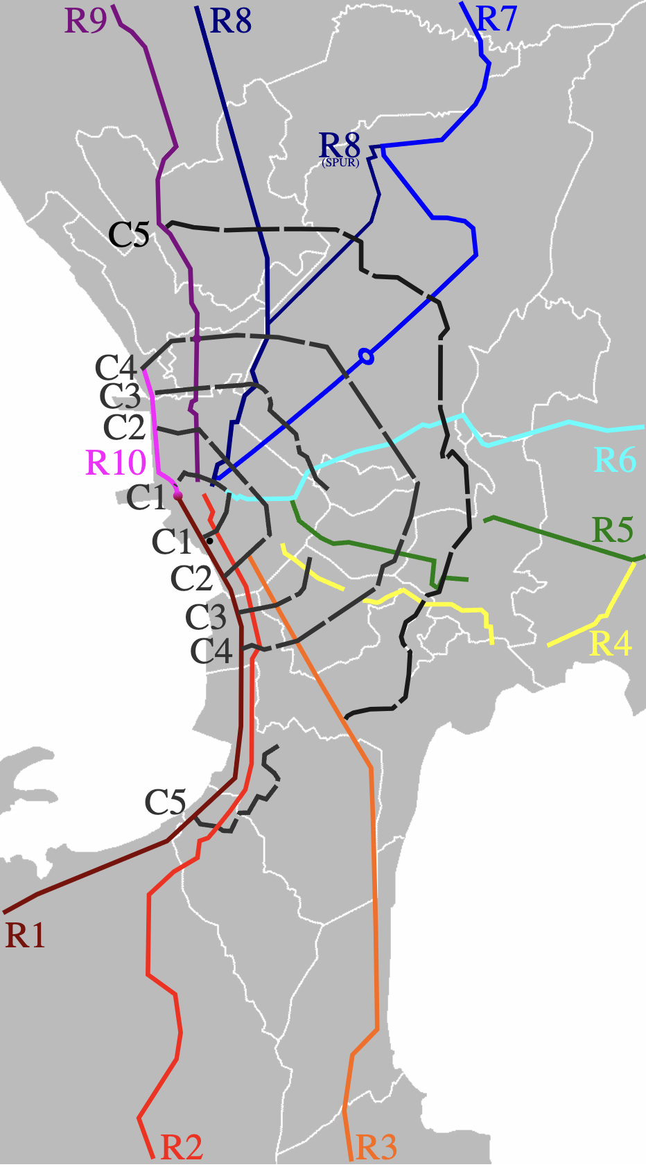
- R1: Roxas Boulevard
- R2: Taft Avenue
- R3: Osmeña Highway (formerly South Super Highway)
- R4: Shaw Boulevard
- R5: Ortigas Avenue
- R6: Magsaysay Boulevard/Aurora Boulevard
- R7: Quezon Avenue/Commonwealth Avenue
- R8: A. Bonifacio Avenue
- R9: Rizal Avenue
- R10: Del Pan/Marcos Highway/MacArthur Highway
Local Roads
According to DPWH, local roads that are not classified as National Primary, National Secondary, or National Tertiary may be classified as follows:
Provincial Roads
Roads that connect barangays through rural areas, major provincial government infrastructure, and/or cities and municipalities without traversing any National Roads. These types of roads connect National Roads to barangays through rural areas and connect to major provincial government infrastructure.
City/Municipal Roads
Roads maintained by city or municipal governments. This could be either local streets at the poblacion (city or town center, downtown area, or central business district), other roads linking the poblacion with provincial or national roads, or roads serving major city or municipal infrastructure without using provincial
Barangay Roads
Barangay Roads are defined as other public roads within a barangay not covered by other classifications.
Expressways
Expressways are highways with limited access, normally with interchanges, which may include facilities for levying tolls for passage in an open or closed system. Based on the Republic Act 2000 or the Limited Access Highway Act, only certain vehicles are allowed on expressways including cars, vans, taxis, SUVs, motorcycles above 400cc, light trucks and buses.
Smaller light vehicles such as motorcycles under 400cc, tricycles, bicycles and pedestrians are prohibited from entering expressways, so it goes to follow that e-bikes and e-scooters can not be used on limited access highways where vehicles are much faster. Overloaded vehicles, oversized cars and dilapidated rides are not allowed on expressways.
Other roads
Other types of minor roads also exist in the country, including Private Roads maintained by private entities, usually real estate developers where access may be restricted. There are also Residential Roads built with the primary purpose of serving homes. These roads are primarily used to access homes (e.g. roads inside residential areas and subdivisions).
Lastly, there are Unclassified Roads considered the least important roads in the network, which are not residential. This includes most other rural roads and roads leading to a barangay with no other links to other barangays or a remote sitio or purok, commercial streets, and local streets in an industrial park. Unlike other types of roads, these roads are mostly unmarked without the need for road signs.
Knowing the different road classifications in the country is crucial for any driver or commuter to ensure their safety, plan their routes effectively, or optimize public transportation systems in case of road restrictions.